

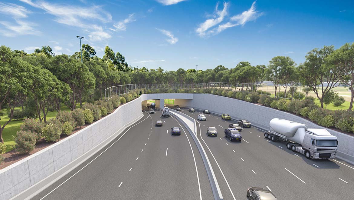
An indicative design of the portal for the motorway at President Avenue, Kogarah, featured in the EIS for Stage 1 of the F6 Extension
The F6 Extension is a proposed project by the NSW Government to extend its WestConnex project south, in order to provide better connectivity to Sydney’s southern suburbs. The project in its entirety is estimated to cost up to $3 billion, and will be built progressively over the next decade, with the first stage of the project set to open by 2024. However, while the project has not been without praise, there has been much criticism directed at the project. Most notably, and that which will be addressed on this page, is the fact that there exists no current intention for the motorway to truly extend the F6 Freeway from Waterfall to Sydney, with the extent of the project only stretching south to the Princes Highway at Loftus. Motorists are then expected to continue to negotiate the congested highway for 12km before arriving at Loftus.
This page will explore the history of the proposal, the current proposed design of the motorway, as well as explore both the criticisms of the current proposal and the responses by the government.
This page will explore the history of the proposal, the current proposed design of the motorway, as well as explore both the criticisms of the current proposal and the responses by the government.
|
History
County Of Cumberland Proposal
The F6 Freeway, officially known since 2013 as the Princes Motorway but still frequently referred to as the former, is the major road link between Sydney and Wollongong. Commencing at Waterfall, the freeway meanders its way along rough terrain for 47km before terminating at Albion Park Rail south of Wollongong. The motorway is an essential link for the city of 300,000, providing the only proper means of road transport north to Sydney bar the original Princes Highway and the scenic Lawrence Hargrave Drive.
Proposals for the freeway floated about during the late 30s and into the 40s. The freeway was officially gazetted in the County of Cumberland Planning Scheme in 1951, with the project commencing at Ultimo in Sydney CBD before snaking through southern Sydney to Waterfall. Subsequently, in 1952, a corridor stretching from Waterfall to Bulli Tops and then on to Dapto was gazetted under the Illawarra Planning Scheme.
The construction of the second half of this proposal commenced in 1959. Construction of this southerly section was subsequently undertaken over the course of the next several decades, with the project reaching completion by 1987, other than several upgrades to the freeway such as the addition of an interchange near Helensburgh in 2000. In a technical sense, the F6 does not exist as a Freeway between Bulli Tops and Gwyneville; instead, the freeway traverses between Waterfall and Bulli Tops, before becoming Mt Ousley Road between Bulli Tops and Gwyneville, and finally a freeway once more between Gwyneville and Yallah. Conditions along Mt Ousley Road, however, resemble a freeway, with grade-separated interchanges at major roads and several at-grade intersections being its only major distinction.
The northerly half of the originally proposed route under the County of Cumberland Planning Scheme, however, was never truly commenced.
The extent of the proposed 1951 route can be seen below, reconstructed in Google Maps. Be sure to zoom in and click on the markers to read more information.
The County Of Cumberland proposal for the project can be viewed here.
However, the proposal for the F6 to be constructed from Ultimo to Waterfall was cancelled in 1977 under the Neville Wran government, alongside a majority of the County of Cumberland proposals, including the F4 Western Freeway east of Concord (now being constructed as the M4 East under WestConnex).
On viewing the above map, one can very clearly see that a significant amount of empty land that at first glance appears randomly placed remains empty purely because it was proposed to be part of the F6. North of Alexandria, a majority of land has been sold off, however a majority of the original reservation for the freeway remains intact south of Alexandria; this explains the dotted parcels of land throughout south Sydney.
To the present day, there has only ever been constructed one section of the F6 north of Waterfall. The 6-lane Captain Cook Bridge at Taren Point was constructed and opened in 1965. Unbeknownst to many, the bridge was constructed with the intention of one day forming part of the F6 when it was constructed. However, with the cancellation of the F6 north of Waterfall in 1977, this left the Captain Cook Bridge as the only existing structure of the F6 within Sydney. The approaches to either side of the Captain Cook Bridge, that both resemble a freeway, can be seen as evidence of this.
Revived Proposals for F6 Extension
The NSW Government has continued to float proposals about the F6 Extension in the decades following its 1977 cancellation. Despite the cancellation of the freeway, a significant amount of land remained gazetted by the government as a freeway reservation afterward, as mentioned earlier. This included parts of the reservation that passed through the Royal National Park. Such land would have been difficult to use without causing public controversy over damage to the environment, and so the government vowed in 1989 to degazette land within the national park; by 1993, however, no progress had been made on freeing up the land.
In September 2002, the possibility for an F6 Extension to be constructed in the future became slimmer when it was announced by the then Minister for Roads Carl Scully that the F6 reservation between Loftus and Alexandria would be scrapped as a freeway corridor, and instead be reserved as a corridor for public transport and recreation, in a sense opening the reservation up to the public. However, this decision was later placed under threat when Michael Costa, Scully’s successor as Roads Minister, announced a renewed intention in 2005 to investigate the corridor and the feasibility of an F6 extension. This decision was met with significant backlash.
In February 2007, the NRMA escalated a campaign ahead of the 2007 NSW State Election for the F6 Extension to receive funding. The organisation proposed the extension begin at St Peters and continue south to Heathcote, with its deputy president Michael Tynan urging that the government “complete the F6 or condemn local residents and businesses to being strangled by endless traffic delays”. The Tourism Transport Forum expressed similar support behind the project, claiming that a 13% reduction in tourism over seven years had been caused by traffic congestion in the Illawarra region. However, the proposal was again met with some backlash, with Barry Collier, the Labor member for Miranda through which much of the freeway would pass, suggesting that the project would be constructed “over my dead body”.
With Labor winning the election, NRMA were disappointed at the 2007 budget released in June, which did not set aside any funds for the F6, although $174 million for road projects in the Illawarra was welcomed. In November 2007, the Federal Coalition ahead of the federal election promised $20 million for funding toward a scoping study for the F6 Extension; however, the coalition did not win the election.
Calls for the F6 Extension were renewed once more by the NRMA in February 2008, after a study found that the extension would deliver a $3 billion economic benefit to Sydney by 2031, with a cost of $2.2 billion to construct but an immediate estimated benefit of $1.1 billion. A reduction in travel times from 70 minutes to 55 minutes between Sydney and Wollongong was estimated. The study proposed a tunnel between Sylvania and Loftus in order to alleviate the concerns of locals. The NRMA once again urged the NSW Government to provide funding for the F6 Extension in November 2010.
The NSW Long Term Master Plan, released in December 2012, listed the F6 Extension as a “long-term priority”, implying that the route may not be constructed for up to 20 years.
A 2014 paper written in response to the Rebuilding NSW (accessible here) recommended that construction of the F6 between St Peters and Waterfall commence by 2020. The paper cited increasing travel times between Sydney and Wollongong (from 70 minutes in 2005 to 90 minutes in 2014) as well as the economic benefit that the project would bring as determined by the earlier 2008 NRMA study.
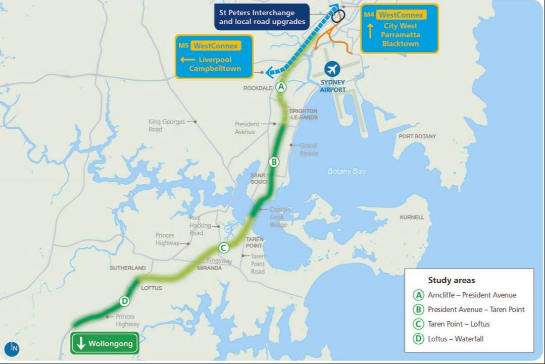
A proposal of the four sections of the project as released in 2016
|
In June 2014, the NSW Government allocated $11 million in the State Budget to commence a feasibility study into the F6 Extension, with the (rather unusual) suggestion being made by then roads minister Duncan Gay that the extension could run through Menai and Alfords Point instead of the Sutherland and St George Shires, meeting the M5 far further to the west. In mid-2016, drilling rigs had been installed throughout the Sutherland and St George Shires in order for tests to be conducted under the study into the F6 Extension. By late-2016, a proposal of a corridor had been released by the RMS, outlining four key sections; Arncliffe to President Avenue, President Avenue to Taren Point, Taren Point to Loftus and Loftus to Waterfall. It was proposed that the project connect with the then-under construction WestConnex at Arncliffe. This proposal can be seen to the left.
|
In late 2016, 140 buyers along the Werrington Arterial Corridor in Western Sydney and the F6 Corridor were told that an “administrative error” by the Government had meant that they were incorrectly sold land and that their homes may need to be removed in the future for proposed road projects.
In December 2016, the NRMA once again launched a campaign to promote what had been F6 Extension or, as it had been temporarily dubbed, the “SouthConnex”. A survey of 850 conducted in the area of the SouthConnex reported that almost three-quarters of residents supported the project.
In May 2017, the RMS commenced further geotechnical investigations in up to 30 sites across the proposed corridor.
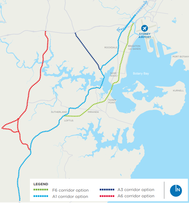
The potential corridor options investigated by the RMS, released in late 2017
|
Project Announcement
The RMS announced in November 2017 that the current F6 corridor, which roughly aligned with the F6 reservation as per the County of Cumberland, had been chosen for the project. Details on this announcement were included in a factsheet, accessible here. The following three corridors had also been investigated:
|
The RMS had determined that a majority of the project would be constructed in a tunnel, in order to minimise local impacts. Geotechnical investigations had allowed the RMS to determine that Stage 1 of the project would best be constructed slightly to the west of the pre-existing F6 corridor.
Cancellation of Stage 4
The F6 Extension was originally divided into four stages, as detailed above. The fourth stage was to commence at Loftus and continue south to Waterfall, most likely cutting through the Royal National Park.
However, a decision was quietly made during late investigations for the project, prior to its original announcement, that this stage would not be constructed. A short phrase in the SSI Stage 1 Scoping Report, released in September 2017 and detailed below, provides limited insight into this decision:
“…it was concluded that development would not proceed on the connection from Loftus to the M1 Princes Motorway in Waterfall, given that the demonstrated need is lower than the rest of the F6 Extension sections.”
This suggests that the decision had been made either due to a higher road standard south of Loftus or a reduction in traffic volume.
However, it is also highly likely that the development was shelved due to environmental concerns. The plan to construct the F6 Extension through the Royal National Park attracted much criticism from the public and the Royal National Park itself over the years. An ABC interview with former NSW Premier Bob Carr from June 2017 can be heard here, with Carr detailing his distate for the proposal.
Further, a government report had previously claimed that up to 500 homes would need to be destroyed for the project were the decision made to not construct the motorway through the Royal National Park. Government papers were said to claim such a proposal would require hundreds of millions of dollars’ worth of property acquisition, whilst a path through the Royal National Park would cost significantly less but potentially have a greater impact on the environment.
Stage 1
SSI Scoping Report
Prior to the official October announcement of the project, in September 2017 the RMS lodged its State Significant Infrastructure (SSI) Scoping Report to support a State Significant Infrastructure application for Stage 1 of the F6 Extension; this report may be viewed here. The scoping reported listed several benefits that would come of the extension as a whole, including improved travel times for residents and businesses in the region, reduced congestion on the arterial and local road networks, and economic growth in the Sutherland Shire and Illawarra.
At this point, concerns brought up by the community were detailed in the report. These ranged from concern over a perceived increase in traffic along President Avenue and the Princes Highway south of Kogarah with the opening of the motorway, concerns over its environmental and health impact, concern over a potential reduction in parking availability along President Avenue, and concerns for pedestrian, cyclist and motorist safety.
The report proposed that Stage 1 of the project comprise of-
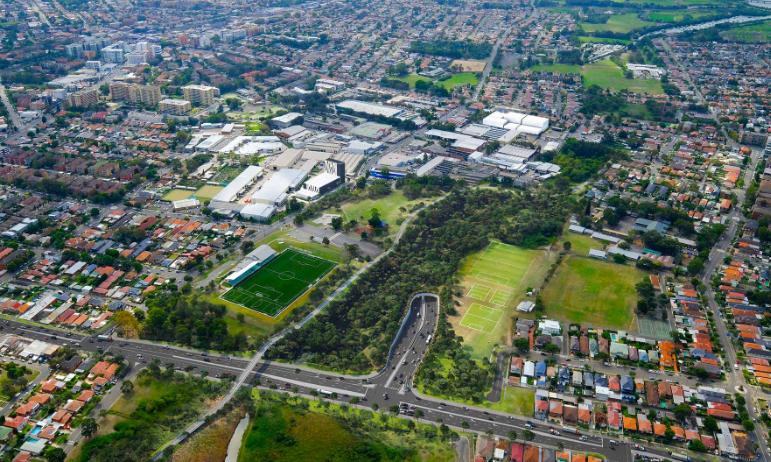
- Twin 4km motorway tunnels between the New M5 at Arncliffe and Rockdale Bicentennial Park.
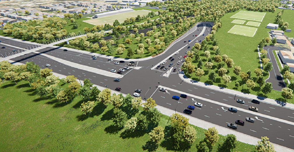
- A tunnel portal and interchange at Brighton-Le-Sands within Rockdale Bicentennial Park (within the existing F6 reserved corridor) connecting to on- and off-ramps to President Avenue, Kogarah
- A widened President Avenue at the location of the interchange with the project, including slip lanes to provide a connection to the project
- Mainline tunnel stubs near the southern end to allow for connections to Stage 2 of the F6 Extension
The report also acknowledged that a reduction in air quality would occur throughout the construction of the project in the area due to construction vehicles, earthworks and numerous other factors. However, it is stated that an expected improvement in air quality will be recorded along roads experiencing a decrease in traffic post-opening. Despite this, it states that a potential decrease in air quality may be recorded near ventilation facilities and within the tunnels.
Several other issues, such as noise, biodiversity, health and economic factors were addressed in the report.
Consultation was subsequently undertaken with the community between October and December 2017. The Community Feedback Summary was released in June 2018 and may be accessed here (more information on public concerns available below).
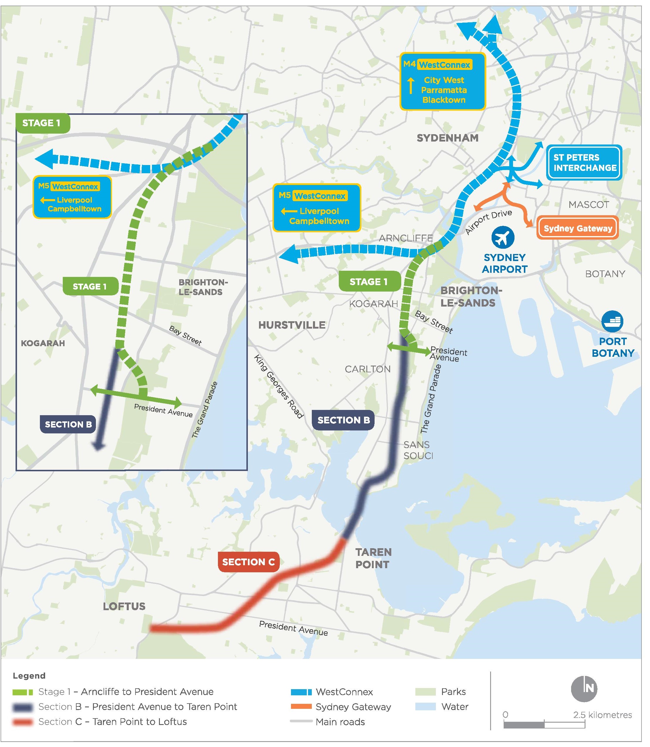
Final Business Case
The Final Business Case was released by Infrastructure NSW in June 2018, which can be accessed here. The government evaluated the cost of the project to be at $2.512 billion; $1.899 billion for construction and $613 million for operation. The Benefit Cost Ratio was calculated to be 1:1.56. That is, for every $1 spent on the project, $1.56 would be returned in some way to the economy. The report also states that construction on the project could begin by 2020 and reach completion by 2024.
The report also included a detailed map of the location of each stage of the project, as can be seen.
Further updates were also announced to the public at this time (which can be seen in this factsheet), including:
- The intention to turn O’Neill Street and Moorefield Avenue at Brighton Le Sands and Kogarah respectively into cul-de-sacs
- Relocation of Rockdale Skate Park during construction
- A shared cycle and pedestrian bridge over President Avenue to the east of the motorway’s southern terminus
- A signalised intersection at its southern terminus with President Avenue
- Northern ventilation facilities located at a new motorway control complex at Arncliffe, and southern ventilation facilities in the industrial zone on West Botany Street
- A greatest tunnel depth of 93m underneath Segenhoe Street
- Shared cycle and pedestrian pathways
EIS
On November 8th 2018, the EIS for Stage 1 of the F6 Extension was released to the public. The EIS may be viewed here. The digital EIS consists of several fairly large files; it may be advisable to view the EIS at one of exhibition locations as detailed via the link. Alternatively, the Project Summary may be read here. An in-depth portal on the project may be viewed here. A video detailing the project was also released at this time by the RMS, and can be viewed below.
On November 8th 2018, the EIS for Stage 1 of the F6 Extension was released to the public. The EIS may be viewed here. The digital EIS consists of several fairly large files; it may be advisable to view the EIS at one of exhibition locations as detailed via the link. Alternatively, the Project Summary may be read here. An in-depth portal on the project may be viewed here. A video detailing the project was also released at this time by the RMS, and can be viewed below.
After further consultation with the community, the EIS was prepared in order to both address concerns, seek further submission from the community, and prepare the project for approval and construction. The EIS stated that the mainline tunnels would be built to three lanes, but marked to two from opening. The tunnels would have a speed limit of 80km/h, in line with most road tunnels in Sydney.
The EIS also listed numerous benefits, including a reduction of 2,000 trucks a day on surface roads, and a bypass of 23 traffic lights as compared to the alternative surface route. The report also detailed construction sites to be established at Arncliffe, Rockdale, President Avenue at the southern terminus of the motorway, and the Princes Highway at President Avenue.
It was stated that excavation of the tunnel would most likely take place using roadheaders that would use drilling and blasting methods throughout the excavation. The report addressed traffic, stating that several changes to roads in the region could occur, including more turning lanes onto President Avenue from the Princes Highway. The report also proposed a shared cycle and pedestrian pathway from Bestic Street, Brighton Le Sands, south to Civic Avenue, Kogarah, through Rockdale Bicentennial Park. Noise levels, air quality and biodiversity were also addressed in the report.
The report estimated that 3,250 jobs would be created between 2020 and 2024 during construction, with a generation of $4.3 billion of local activity during construction.
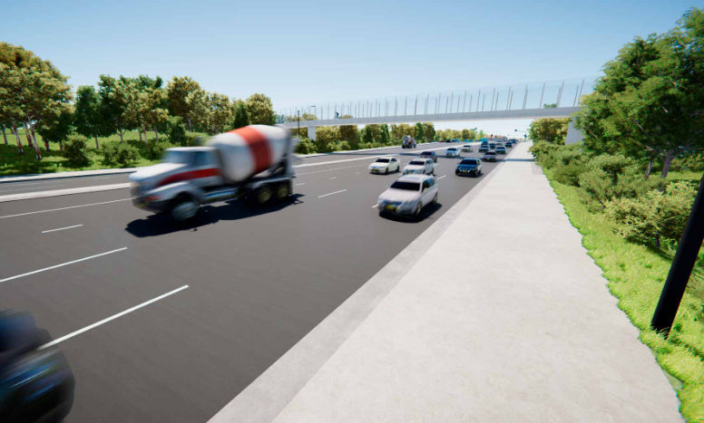
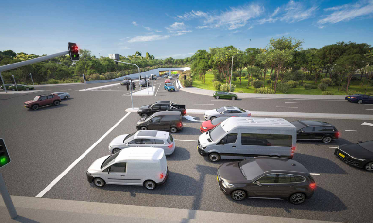
Prospective designs of the project as included with the EIS may be viewed below, as can an interactive map of the EIS proposal.
The EIS also listed numerous benefits, including a reduction of 2,000 trucks a day on surface roads, and a bypass of 23 traffic lights as compared to the alternative surface route. The report also detailed construction sites to be established at Arncliffe, Rockdale, President Avenue at the southern terminus of the motorway, and the Princes Highway at President Avenue.
It was stated that excavation of the tunnel would most likely take place using roadheaders that would use drilling and blasting methods throughout the excavation. The report addressed traffic, stating that several changes to roads in the region could occur, including more turning lanes onto President Avenue from the Princes Highway. The report also proposed a shared cycle and pedestrian pathway from Bestic Street, Brighton Le Sands, south to Civic Avenue, Kogarah, through Rockdale Bicentennial Park. Noise levels, air quality and biodiversity were also addressed in the report.
The report estimated that 3,250 jobs would be created between 2020 and 2024 during construction, with a generation of $4.3 billion of local activity during construction.
Prospective designs of the project as included with the EIS may be viewed below, as can an interactive map of the EIS proposal.
Public Response and Criticism
A significant amount of criticism has been directed to the F6 Extension over the years, escalating ever since its announcement in 2017. The following issues have been most significant to the community and wider public, primarily in the aforementioned Community Feedback Summary (accessible here):
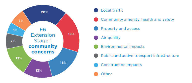
- Local traffic and congestion
- Environmental impact on Rockdale Bicentennial Park
- Property and land use impacts
- Noise
- Public health
- Business Impacts
- Perception that WestConnex operators will benefit
An NRMA study conducted in May 2018 revealed that the entire project could cost anywhere between $8.6 billion and $10.4 billion. The study also indicated that an increase in traffic of 26% would occur on President Avenue at Kogarah, increasing to 37% with the completion of Stage 3. The impact of Stage 1 on surrounding roads, that the project claimed it would relieve, would be minimal; 9% on the Princes Highway at Rockdale, and 5% on General Holmes Drive. Conversely, the study did reveal the project would bring $677 million a year worth of economic benefits from 2031.
Several concerns were addressed in the EIS.
Since the southern terminus of Stage 1 is located within the Rockdale Bicentennial Park, the park shall not be in use throughout construction. The RMS has thus vowed to allocate $20 million in developing “new and upgraded facilities to compensate for this loss of recreational and open space, and reinstate the facilities at the end of construction.” Ador and McCarthy Parks, located 1km north of the Rockdale Bicentennial Park, will be upgraded, including a new skate park and an upgrade of the McCarthy Park field to full-size. Brighton Memorial Playing Fields will also be upgraded. On completion of the project, the East Bicentennial Playing Fields will be returned to the community.
Measures to limit noise levels during construction include use of acoustic sheds at the Rockdale and Arncliffe sites, as well as site hoarding (barriers around the sites to limit noise).
It has been claimed by the RMS in their EIS project summary that, with regard to air quality, “Under expected traffic conditions for the project, the predicted contribution of tunnel ventilation outlets to local air quality was negligible.”
Protests have been frequent ever since the project’s announcement, with such groups as the "F6 Action", formed in 2017 to raise public concerns about the project. Accusations that the project will benefit the WestConnex operators, by feeding more traffic into its system, has dogged the project. Further, the decision to not extend the project to Waterfall has been viewed by many as short-sighted, with some questioning why the project is known as the F6 Extension despite no intention for the project to ever join the F6. Finally, some public criticism lies in a preference for the prioritisation of public transport over a new motorway.
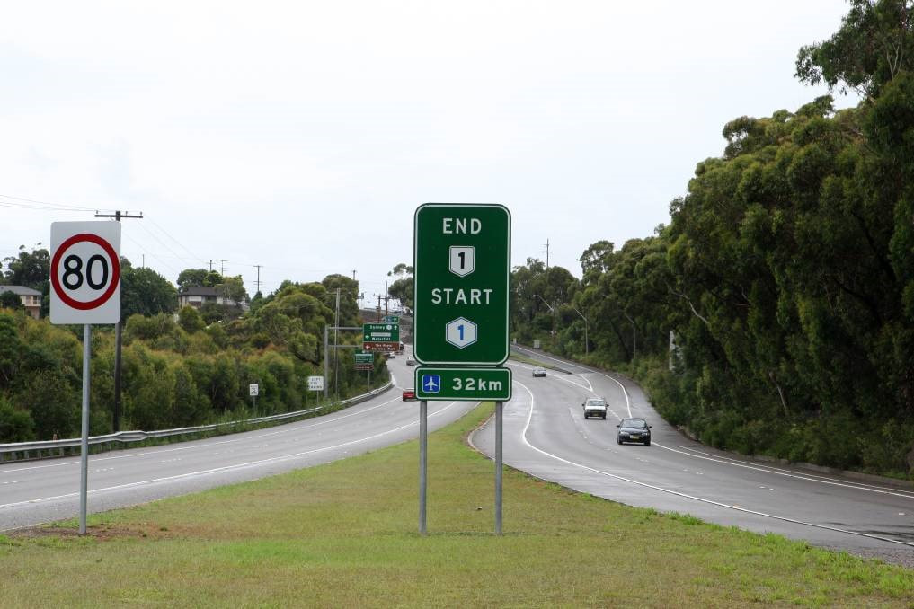
The current terminus of the F6 at Waterfall. There is no current intention for the F6 Extension to ever meet the F6 at Waterfall. Image courtesy of Illawarra Mercury
|
My Opinion Normally I would be the first to support a new motorway. Sydney has one of the sparsest freeway networks of any major city in the world, the result of decades of cancellations and inaction by successive governments. Yet my issue with the F6 Extension is itself purely from a road perspective; it is a motorway that does not appear to be aiming to properly address the needs of Sydney motorists. It does not seem that the project will effectively solve the problem of congestion in south Sydney and beyond. |
Whether or not the project is being constructed by the government intentionally to support the WestConnex and its toll operators, as many believe, is debatable. In all honesty, while the prospect that private investors will benefit significantly from the project does not entirely please me, from a road perspective so long as the road helps to reduce congestion, I am fine. Except, of course, I am not entirely convinced that this motorway will help the community.
First and foremost, the fact that the F6 Extension is not set to meet the current F6 at Waterfall is unusual and disappointing. To have a roughly 12km gap between Loftus and Waterfall will have a significantly adverse impact on traffic. Currently, the Princes Highway between Loftus and Waterfall is the least trafficked portion of the highway, however this is irrelevant. Once the project is completed, traffic will be dumped onto the highway at Loftus, shortening the time for cars to arrive at Loftus and thus increasing congestion along a road not constructed to handle the resultant influx in traffic. A full motorway link between Wollongong and Sydney has been promised for decades, and that this may never happen due to a short 12km gap is problematic. The RMS may not see it now, but as much as I hope to be wrong, this choice will likely be a costly mistake.
I should state that I am aware that most plans in the past to construct a motorway within the gap would involve destroying parts of the Royal National Park, which is why I believe the government should take great care with any designs to construct this missing link, investigating alternatives to building through the national park, most probably with a tunnel. This would be costly, but in the long-term a necessity.
|
The choice to end Stage 1 at President Avenue, Kogarah, seems risky. Rather than a grade-separated interchange independent of traffic lights, similar to the M4 East interchange with Paramatta Road at Haberfield, the intersection will be at-grade. Granted, this will only be a short-term issue, yet it will significantly increase traffic along the President Avenue corridor that is trying to get to the Princes Highway. Ending the project at the Princes Highway at Rockdale itself, with a grade-separated interchange, would have been more logical in my opinion, limiting congestion between Stage 1 and Stage 2 completions. This is not a significant problem in my opinion, however, since the southern terminus is only temporary.
|
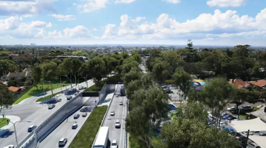
An indicative design of the M4 East portals at Haberfield on opening in 2019
|
The current route that traffic generally takes from Sydney CBD to Wollongong is along the A1/M1-F6 corridor, which traverses the Eastern Distributor and General Holmes Drive, along with several other interconnecting roads. Yet there is no intention for Stage 1 of the project to connect to General Holmes Drive. Thus, vehicles intending to travel from Sydney CBD to the south via the F6 Extension will have several route options, the motorway option being along the Western Distributor and the Anzac Bridge to the Rozelle Interchange, then south along the WestConnex M4-M5 Link to the St Peters Interchange, then down the WestConnex New M5 to the F6 Extension. It is easy to see how this route will significantly benefit operators of the WestConnex.
In all honesty, however, it is not the benefit to toll companies as a result of this road that concerns me. Rather, it is the potential lack of any benefit to the public as a result of the motorway; tolls can significantly detract users. Australia has been host to many toll road failures, such as the Clem Jones Tunnel in Brisbane. That this road may be constructed and fail to serve its purpose would be a huge disappointment.
Stage 1 of this project is ridiculously short. It does not come even close to the F6, and more importantly it does not bypass an existing corridor effectively, instead making its own corridor starting at the St Peters Interchange. An expensive toll is already highly likely to repel users, primarily due to the routing of the motorway that encourages users onto the expensive WestConnex. The fact that Stage 1 is so short, barely getting motorists past the Inner South (until the construction of Stage 2 at an unknown date in the future), will only further detract users from the road. As a result, congestion will remain on surface roads, rendering the project a failure.
On the flipside, if the project is not extended to Waterfall, congestion after completion could in fact become more severe on the 12km gap, creating a bottleneck between two high-speed motorways that will harm the overall productivity of Sydney’s link to the south.
I do, on the whole, support the construction of the project, but I believe that it is important that both the public and government remain aware that there is no guarantee that this new motorway will decrease congestion. Unless changes are made to the project, and extreme care is taken to prevent any failures on the scale of projects like the Clem7, it is entirely possible that the motorway will never fulfil its true purpose of reducing congestion between Sydney and Wollongong.
Resources
Official F6 Extension RMS Page- https://www.rms.nsw.gov.au/projects/sydney-south/f6/index.html
F6 Extension Stage 1 EIS and SSI Reports- http://majorprojects.planning.nsw.gov.au/index.pl?action=view_job&job_id=8931
F6 Extension Stage 1 EIS Portal- https://v2.communityanalytics.com.au/rms/f
F6 Extension Stage 1 EIS and SSI Reports- http://majorprojects.planning.nsw.gov.au/index.pl?action=view_job&job_id=8931
F6 Extension Stage 1 EIS Portal- https://v2.communityanalytics.com.au/rms/f
- https://www.ozroads.com.au/NSW/Freeways/F6/construction.htm
- https://www.rms.nsw.gov.au/projects/sydney-south/f6/index.html
- https://majorprojects.accelo.com/public/058b5407a5f3d1f9c9bc80e182d22e3b/F6%20_New%20M5%20to%20President%20Avenue_%20SSI%20Scoping%20Report.pdf
- http://majorprojects.planning.nsw.gov.au/index.pl?action=view_job&job_id=8931
- https://www.rms.nsw.gov.au/documents/projects/sydney-south/f6/f6-project-overview-201811.pdf
- https://www.rms.nsw.gov.au/documents/projects/sydney-south/f6/f6-extension-options-fact-sheet.pdf
- https://www.rms.nsw.gov.au/documents/projects/sydney-south/f6/f6-extension-stage-1-project-overview-2018-06.pdf
- https://www.theleader.com.au/story/5108436/new-group-to-fight-f6-extension/
- https://www.abc.net.au/news/2017-11-03/nsw-government-documents-reveal-houses-to-go-for-sydney-f6/9112404
- https://www.theleader.com.au/story/5722514/why-call-it-the-f6-extension-if-it-wont-extend-to-the-f6/
- https://www.theleader.com.au/story/5744903/highway-intersection-to-be-upgraded-for-f6-extension/
- http://www.infrastructure.nsw.gov.au/media/1664/f6-extenstion-stage-1_fbc-summary_final.pdf
- https://www.illawarramercury.com.au/story/5426454/f6-extension-to-cause-traffic-chaos-cost-104b-nrma-report/
- https://www.smh.com.au/opinion/westconnex-latest-attempt-to-ram-through-a-thoroughly-discredited-freeway-scheme-20141123-11s5xu.html
- https://www.theleader.com.au/story/4955984/high-rise-fears-on-f6-route/
- https://www.drive.com.au/motor-news/shire-will-become-car-park-unless-f6-is-built-nrma-20070226-140d8
- https://www.smh.com.au/national/nrma-calls-for-extension-of-f6-20070227-gdpk68.html
- https://www.abc.net.au/news/2007-06-22/nrma-unhappy-with-f6-freeway-budget-snub/77344
- https://web.archive.org/web/20101128193756/http://www.mynrma.com.au/cps/rde/xchg/mynrma/hs.xsl/6065.htm (link to archive)
- https://www.illawarramercury.com.au/story/603418/nrma-call-to-extend-f6/
- https://www.fullyloaded.com.au/industry-news/1011/its-time-to-build-f6-extension-nrma
- https://www.illawarramercury.com.au/story/1185293/f6-extension-could-take-another-20-years/
- http://www.rdaillawarra.com.au/assets/Australian-Infrastructure-Audit-Illawarra-Submission/IBC-and-RDA-Illawarra-Submission-to-the-Infrastructure-Audit-Appendix-2-Advancing-Infrastructure-in-the-Illawarra.pdf
- https://www.theleader.com.au/story/2360315/f6-extension-takes-on-a-twist/
- https://www.nsw.gov.au/your-government/the-premier/media-releases-from-the-premier/busting-congestion-300-million-to-create-a-gateway-to-the-south/
- https://www.theleader.com.au/story/4082636/f6-extension-tests/
- https://infrastructurepipeline.org/project/f6-corridor---stage-1--extension-project/
- https://www.afr.com/real-estate/nsw-misleads-140-into-buying-homes-in-path-of-a-freeway-20161028-gsd9c8
- https://www.rms.nsw.gov.au/projects/sydney-south/f6/project-documents.html
- https://www.rms.nsw.gov.au/documents/projects/sydney-south/f6/f6-corridor-fact-sheet.pdf
- https://www.rms.nsw.gov.au/documents/projects/sydney-south/f6/f6-extension-options-fact-sheet.pdf
- https://www.rms.nsw.gov.au/documents/projects/sydney-south/f6/f6-extension-ssia-application-fact-sheet-summer-2017.pdf
- https://www.rms.nsw.gov.au/documents/projects/sydney-south/f6/f6-extension-community-update-october-2017.pdf
- http://www.illawarramercury.com.au/story/4729049/the-challenge-of-the-f6-extension/
- https://www.abc.net.au/news/2018-02-17/nsw-transport-rally-through-sydney-cbd/9458116
