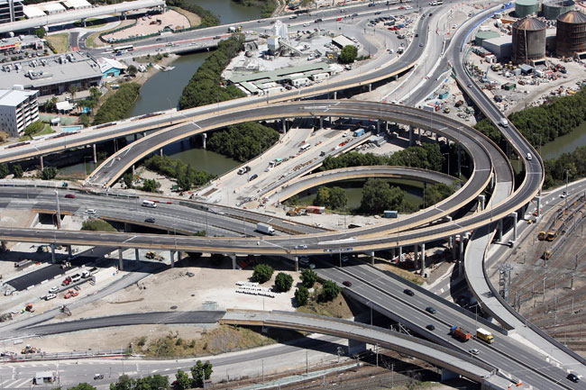
One crazy interchange; looking at the junction of the Clem Jones Tunnel, Airport Link and Inner City Bypass in Brisbane; Courtesy of Courier Mail
Interchanges involve freeways, generally allowing traffic to leave a freeway without disrupting traffic flow on the freeway. This is known as grade-separation; one road passing over another, with ramps allowing for flow between the roads.
While generally they are exclusive to freeways, interchanges can also be built to improve traffic flow on normal roads, such as Ryde Road and the Pacific Highway at Pymble, Sydney, and Wilson Street and the Great Northern Highway at Port Hedland.
There are many forms of interchanges that exist within Australia, all listed below, drawn by me. The drawings are a little dodgy, I know (I drew them in Word), but they serve their purpose at showing the logistics of each interchange.
Common Interchanges
|
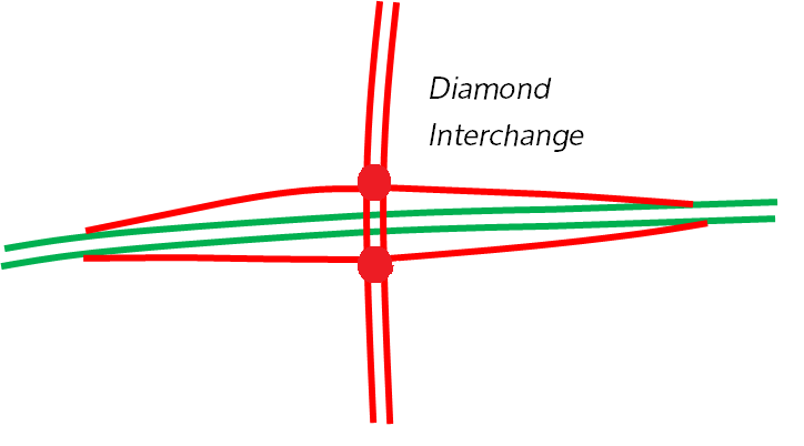
Diamond Interchange
This form of interchange is the most common in Australia. It is also one of the most simple complete interchanges; traffic exits the freeway, arriving at a traffic light, before choosing which direction to turn onto the main road. Similarly, traffic on the main road chooses which turn to take, before entering the freeway. The biggest limitation on this form of interchange is that traffic lights are almost certainly required. Traffic exiting or entering the freeway wishing to turn right must cross over the main road, which causes stop-start traffic, a key downfall. Examples of this interchange can be found simply by opening up Google Maps and finding a random interchange on a freeway; they’re just that common. However if you're desperate the pictured interchange is an example located at the Western Motorway and Cumberland Highway interchange in Sydney. |
|
|
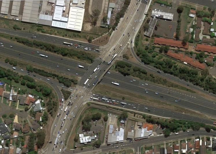
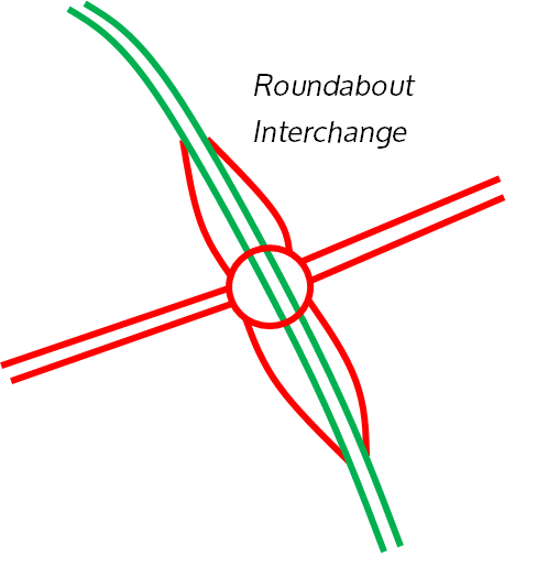
Roundabout Interchange This form of interchange is practically identical to the diamond interchange, and is also complete, with the difference in that a roundabout directs traffic rather than traffic lights. Do not be mistaken though; this roundabout is very big, and usually with a hollow centre which looks into the freeway. This interchange is much more efficient on rural freeways, and hence are common on these, since little traffic uses the interchange. It is very good at directing traffic, in the same nature as a normal roundabout. Examples of this interchange include Main Street and the Hunter Expressway west of Newcastle, NSW and at the Sunshine Motorway and Suncoast Boulevarde on the Sunshine Coast, QLD (pictured below). |

|
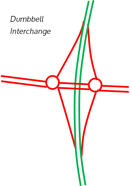
Dumbbell Interchange
This complete interchange is similar to the roundabout interchange however uses two smaller roundabouts rather than one larger one. It is also common rurally.
This interchange is used at the Gulgan Road and Pacific Highway interchange in the far north of NSW, and at the Princes Highway and Princes Freeway interchange east of Melbourne. There are several along the Northern Expressway north of Adelaide as well.
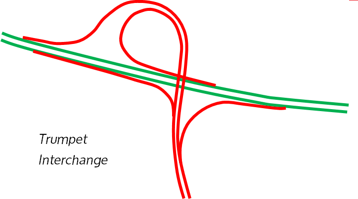
Trumpet Interchange
The trumpet interchange allows free-flow between both roads, involving one road terminating on the other. Named such due to its shape, it also helps conserve space as the loop for traffic entering the freeway can share a ramp with the ramp exiting, while still being a complete interchange.
An example design in use is the junction of the Citylink and Westgate Freeway in Melbourne, at the Peats Ridge Road and Pacific Motorway interchange north of Sydney, and at the Roe Highway and Mitchell Freeway Interchange in Perth. Note that the Citylink Interchange is actually inverted; the loop is used for traffic exiting, not entering, the West Gate.
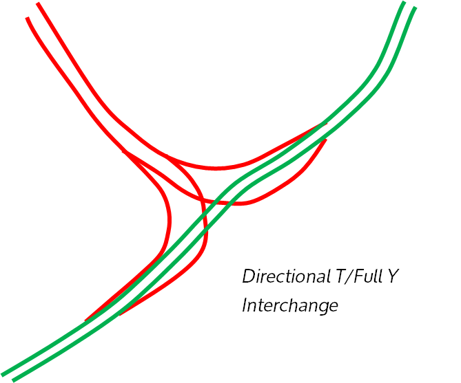
Directional T/Full Y Interchange-
This complete interchange also involves one road terminating on the other. However a flyover takes the place of a loop used in a trumpet interchange. This is advantageous as traffic does not need to slow down to exit or enter the freeway, as is the case with the loop in a trumpet.
Examples of this form of interchange include the junction of the Princes Freeway and Western Ring Road in Melbourne, the Hume Motorway and Westlink in Sydney and the Port of Brisbane Motorway and Gateway Motorway in Brisbane.
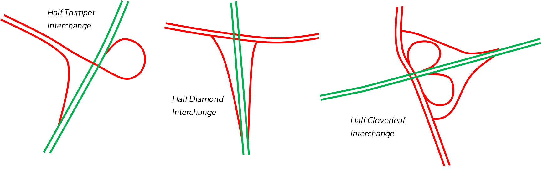
Half-Interchanges-
These interchanges are most commonly used for the same purpose as their full-counterparts, however halved due to small volumes of traffic, or another interchange further up the freeway serving the purpose of the other missing half. Naturally these interchanges are incomplete other than the Half Cloverleaf.
Half-Trumpet Interchange- Example at the Pacific Highway and Pacific Motorway north of Sydney, and the Cahill Expressway and Bradfield Highway near Sydney CBD.
Half Diamond Interchange- Example at the Mitchell Freeway and Erindale Road in Perth; note that Windsor Road and Hills M2 in Sydney was formerly a Half Diamond before conversion into a full diamond. A one-sided half diamond can be observed at the Christy Road and M2 Interchange in Sydney.
Half Cloverleaf Interchange - Example at Mitchell Freeway and Pinjarra Road interchange in Perth and Bradman Avenue and Sunshine Motorway at the Sunshine Coast, QLD. Saves space compared to a Diamond interchange.
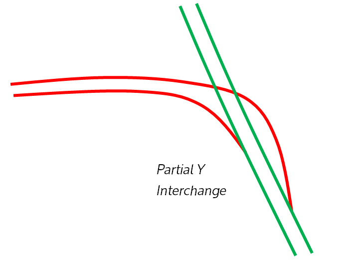
Partial Y-interchange-
This particular interchange is used commonly in bypasses; for example, Southern Cross Way and the Gateway Motorway in Brisbane at both ends (SCW was bypassed by the Gateway in 2010).
Obviously going south on the Gateway, traffic would not need to then go north on Southern Cross Way, and vice versa, hence only a partial, incomplete interchange.
Another example is the Norwest Boulevarde and the Westlink interchange in Sydney; its use in this case is since the Old Windsor Road interchange further up serves the purpose of the other half of the interchange. A final example is at the South Eastern Freeway and Mt Barker Road Interchange east of Adelaide.
(Fairly) Uncommon Interchanges
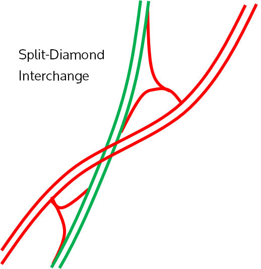
Split Diamond Interchange
I couldn’t find the exact name for this kind of interchange, so I named it myself; it essentially performs the same function as a diamond interchange, however it is split up as shown in the diagram. It is still a complete interchange.
This interchange is in use at the Helensburgh Interchange between the Old Princes Highway and Princes Motorway south of Sydney. The interchange at the Sturt Highway and Mallala Road north of Adelaide is fairly similar.
|
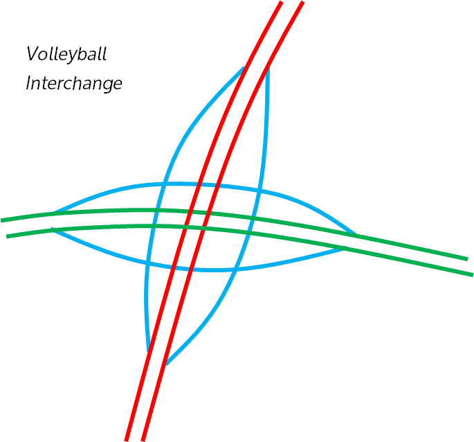
Volleyball Interchange
Volleyball Interchanges, named such due to the pattern of the ramps, are essentially diamond interchanges, except that they have 3-levels; one for the road, one for the freeway and one for the ramps. Traffic on the road exits and then turns either right or left onto the freeway. Also, traffic on the freeway exits then turns either right or left onto the road. All of this occurs without disruption to the flow of either road. Personally I believe it is a very clever, and efficient, design. I chose to draw the ramps in blue for this diagram. If the design confuses you, think of it like a roundabout; the roundabout allows traffic to choose which direction to leave it in. The only real difference between the roundabout interchange and volleyball interchange is that this ‘’roundabout’’ (which usually uses traffic lights) is separated from the two roads. I honestly did not think this interchange existed in Australia until I came across the Gateway Motorway and Old Cleveland Road interchange in Brisbane. It is the only Volleyball interchange in the country, however the Sunshine Motorway and Maroochydore Road interchange does come close, except it is actually a modified roundabout interchange, instead using traffic lights, as you can clearly see here. |
|
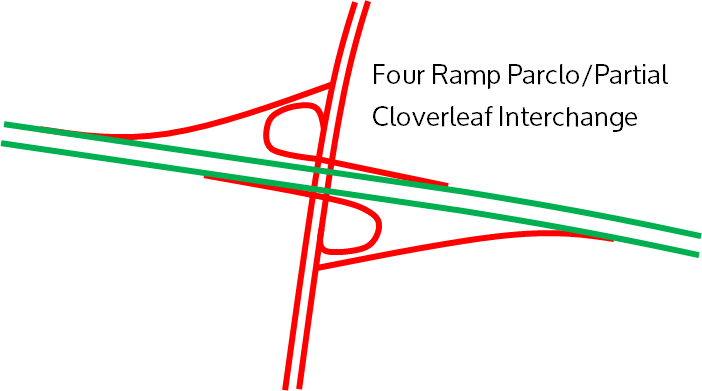
Four Ramp Parclo Interchange/Partial Cloverleaf Interchange
This form of interchange is fairly rare; I have only found one example in Sydney, at the M4 Motorway and Mamre Road interchange. This junction serves the same purpose as a diamond interchange however conserving space (two of the four quadrants around the freeway are not used). However, the tight loops are a natural disadvantage, meaning traffic must slow around these turns.
This form of interchange is fairly rare; I have only found one example in Sydney, at the M4 Motorway and Mamre Road interchange. This junction serves the same purpose as a diamond interchange however conserving space (two of the four quadrants around the freeway are not used). However, the tight loops are a natural disadvantage, meaning traffic must slow around these turns.
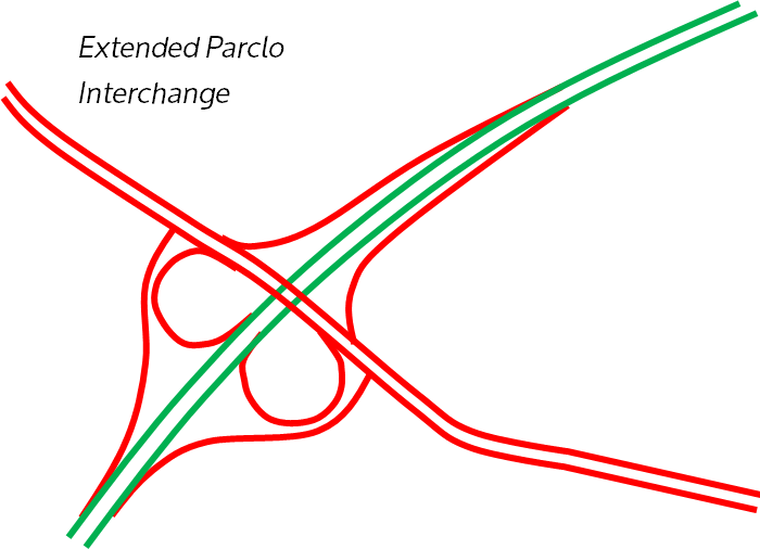
Extended Parclo Interchange
This form of interchange is essentially a diamond interchange with two loops added. It can also be viewed as the combination of a half cloverleaf and half diamond interchange. Regardless, it is a complete interchange that is capable of handling large traffic volumes, only two ramps short of a complete interchange requiring no crossing over the road.
This interchange is used at the Narellan Road and Hume Motorway Interchange south of Sydney, and is otherwise rare. It is slightly hard to tell, but this interchange at the Pacific Highway and Lane Cove Tunnel just west of Sydney seems to also be an extended Parclo.
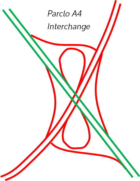
Parclo A4 Interchange
This form of interchange is complete as well, and simply means traffic on the road can access the freeway without stopping at any traffic lights; only traffic exiting needs to do this.
Again, this interchange is fairly rare. I have found an example of it in Port Hedland, in the Pilbara, WA, at the junction of Wilson Street and the Great Northern Highway. However, traffic on the highway going west, for example, must turn right to go north in Port Hedland, and vice versa, as traffic does not stop at Wilson Street, rather merging. Information on the now complete project can be accessed here.
I believe it to be the most isolated interchange in Australia; it is roughly 1400km from the next nearest interchange in Geraldton. Actually, it is probably the most isolated interchange in the world; most interchanges in isolated places have another one nearby in the same locality unlike this one.
Another example of this interchange is at the Sunshine Motorway and Nilkin Way interchange on the Sunshine Coast, QLD. This is unique because the Sunshine Motorway makes a 90 degree turn here; it is still a Parclo A4.
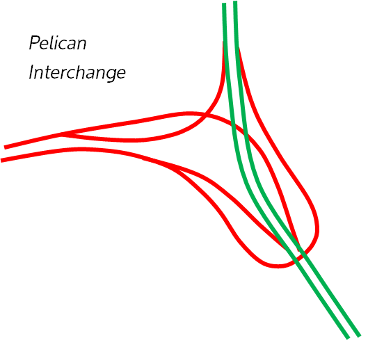
Pelican Interchange
This interchange is certainly rare; I found it at the intersection of Burns Bay Road (the formerly proposed F3 Extension) and Victoria Road in Sydney.
It is complete, and otherwise identical to a directional-T interchange, with the key difference that the traffic wishing to cross over the freeway to exit performs an almost 180 degree loop to join up with it. It seems like an unusual design at first, but at this interchange Victoria Road is gradually climbing into a bridge, hence why the loop could slot neatly underneath it.
The Logan Motorway and Pacific Motorway interchange in Brisbane is also a pelican.
Weird & Notable Interchanges
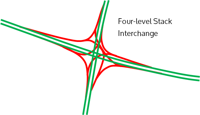
Light Horse Interchange
This is almost definitely the most impressive interchange; at least, that you’ll find in Australia. Only one of these exist in the country; the Light Horse Interchange at the junction of the M4 and M7 in Sydney.
A four level stack is quite literally four levels stacked upon each other; one level for the lower freeway, one for traffic exiting that freeway entering the other, one for traffic exiting the other freeway entering the first, and one for the other freeway.
Although, important to note is that technically the Light Horse Interchange is a five level interchange, as Wallgrove Road has a full diamond interchange with the M4 at this location as well.
The need for this type of interchange in Australia is limited; there are no other complete (that is, full access from all directions) freeway-to-freeway interchanges in the entire nation, let alone Four-level stack interchanges. The main reason is a lack of traffic or any navigational benefit from this interchange being used, but also a lack of freeway-to-freeway interchanges in the first place.
There will almost certainly not be any in the future either, although the future WestConnex interchange in Sydney at St Peters looks as though it comes close; read more here.
|
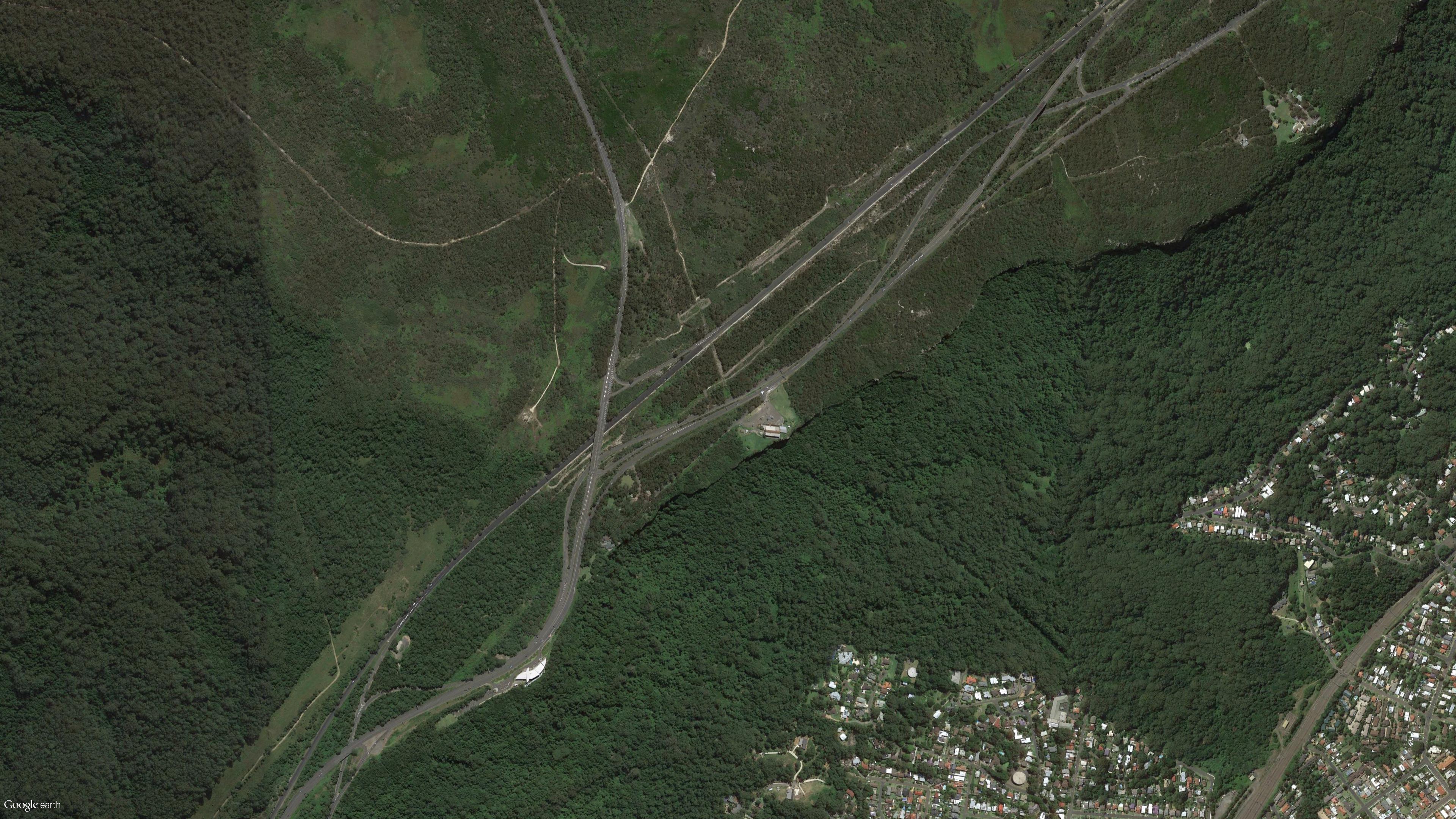
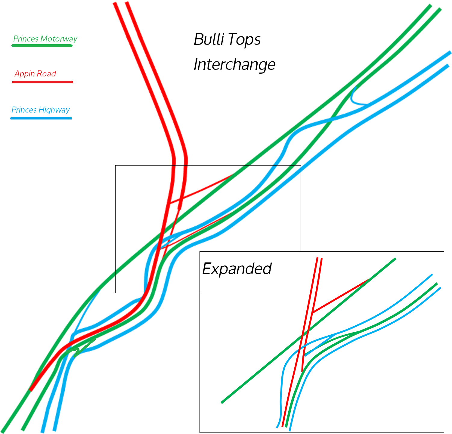
Bulli Tops Interchange
This interchange has got to be the most confusing interchange in the entire country. It is located south of Sydney and north of Wollongong, and is simply bewildering; an exit northbound to continue on the Princes Motorway, with the Princes Highway merging for a short time with the freeway before diverging again, and to add to the mix Appin Road with an extremely peculiar termination at the freeway. If none of that made any sense to you, you certainly don’t stand a chance with the above image, which highlights its perplexing design. That is why I have made up this image which shows all the exit configurations. To make it clearer, the Princes Motorway (former F6) is in green, the Princes Highway is in blue and Appin Road is in red. Even with this diagram I’d be surprised if you can understand this interchange. It is a combination of two partial-y interchanges at both Princes Highway interchanges, with a modified semi-directional T interchange catering for Appin Road traffic. Honestly, I’m not sure what was going through the minds of the engineers who made up this interchange. However, sources show that it was built this way due to the difficult terrain of Bulli Pass, and in fact was never completed; perhaps if it was, it would look much neater than the mess it is today. Regardless, it is navigable, and certainly the interchange doesn’t pose as much of a hazard as the steep Bulli Pass itself. For a better (but also confusing) diagram visit this Ozroads page. |
|
|
Bowen Hills Interchange
While doing my research for the Clem7 economic disaster, I found this nightmare of an interchange, the interchange of the Inner City Bypass, Clem Jones Tunnel and Airport Link (viewed in image at the top of the page). Click on the diagram to see an animation. (see just the interchange here) I chose to make a GIF which shows all the connections; Lutwyche Road/Bowen Bridge Road in orange on the left, with Campbell Street in orange on the bottom right. The Airport Link is in Blue, the Inner City Bypass in Green and the Clem Jones Tunnel in red. As can be seen the interchange is actually simply a partial-y interchange combined with a modified trumpet. The CBD connections are extremely confusing but work fairly well; it seems like such an unneccessary interchange though, considering the lack of traffic on both the Clem7 and Airport Link. Thank heavens almost no one uses either the Clem7 or Airport Link, or they’d have a nightmare navigating this interchange. (In all fairness it’s probably not that hard to navigate, just hard to understand). |

|
Any interesting comments? Leave them here.
