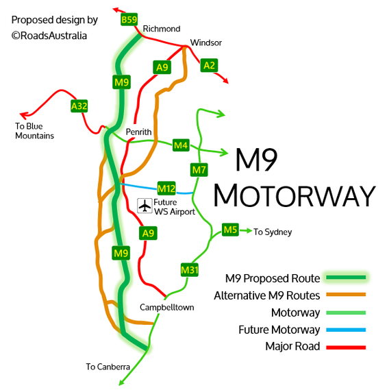
Search the site...

ROADS AUSTRALIA
  • Home
  • New South Wales
    • Sydney's Freeways
    • SYDNEY FUTURE TRAIN NETWORK PROPOSAL
    • NSW's Rural Freeways
    • Sydney's Arterials
    • Sydney's Future Roads
    • Traffic Cameras in Sydney
  • Victoria
    • Planned Routes of Victoria
    • Victoria's Freeways
  • Queensland
    • Queensland's Freeways
  • Tasmania
    • Tasmania; Special
  • Miscellaneous
  • About
  • Sitemap

M9 MOTORWAY

roadsaustralia design proposal
Picture
An RMS sign announcing updates along Richmond Road (A9). Although upgrades are being undertaken along the A9, plans are underway for construction of a new M9 Motorway set to supersede the A9
The A9 is a route through the extreme outskirts of metropolitan Sydney, joining Campbelltown with Penrith and Windsor. Currently the route plays a vital role in linking these three centres of the ever-expanding Western Sydney.
Western Sydney is the fourth biggest city in Australia in its own right. With various developments rapidly underway across Western Sydney, stretching from Campbelltown to Penrith and even Windsor, it is clear that the region is slowly becoming a global city. By 2025 the region will host its own airport, the Western Sydney Airport at Badgerys Creek. Housing developments across the region match Sydney, new housing areas including Oran Park and Marsden Park.
Currently upgrades are being undertaken along the A9, a primary arterial through the region. Although these upgrades are welcomed in coping with the growing region, it is clear that these upgrades will only be sufficient for at most 20 more years. It is for this reasons that the M9 Motorway has been proposed by the NSW Government.
The M9 Motorway was first mentioned in June 2014 by the State Government in the NSW Budget (read the article here). The motorway was mentioned as an Outer Sydney Orbital Corridor, with $4.6 million set aside for alignment investigations and land preservations; getting the route ‘shovel-ready’. The project was announced again in the State Budget nearly 3 years to the day later in June 2017 (read the article here). Along with two other motorway corridors, $2.09 million was set aside for further planning towards the M9 Outer Orbital, which is interestingly half of that given three years earlier. 
Picture
The design released in 2014 by the Government shows the M9 corridor to the far left. The route is very vague, with no terminus indicated, stretching south towards Mittagong and north towards Singleton.
Picture
The design accompanying the 2017 Daily Telegraph article with the reannouncement of the corridor. The route seems more curved, with terminus pictured at Menangle and Box Hill.
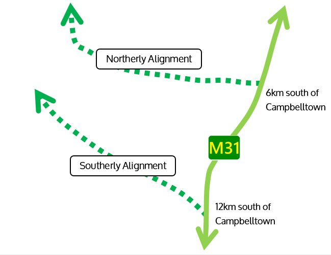
Looking at these low numbers, it is clear that the M9 Motorway is unlikely to be constructed in the near future, with priority instead targeted at planning the route and preserving the corridor. However, even though it could be many decades before construction can even start, it is vital that the corridor is preserved. Planners must determine the best route for the M9 Motorway to take before buying land to allow for construction once funding is available and the Government views the project as a priority. This process has been commonly undertaken on prior projects such as the M4 East (although this land was then rather foolishly sold off by Neville Wran in 1977; read more on site Ozroads here).
Since the identification of the corridor of preservation required is so necessary, I decided to create a design for the M9 Motorway myself. The design assumes that the motorway will be entirely above ground. This design was done carefully, to avoid existing houses, while also going over easy terrain, and most importantly taking a logical route from south-western Sydney to north-western Sydney.
As a result, several corridors were identified. A combination of the various identified corridors was chosen, forming the RoadsAustralia proposal for the route of the M9 Motorway, which can be seen below. View the image in a bigger size here.
Picture
A specific map which shows the exact route of the M9 Motorway, as well as the other potential routes, can be viewed below (or through this link). It was by using Google MyMaps that I was able to create this proposal. View the map in ‘satellite’ mode to get a clearer idea of the land being traversed, and the low amount of house acquisitions required for the route.
There are three main variations to the current alignment that are possible. There is a poll under each alignment asking which you prefer, allowing me to have a better idea of which alignment the M9 should take, so be sure to answer.
Entry to M31
​​
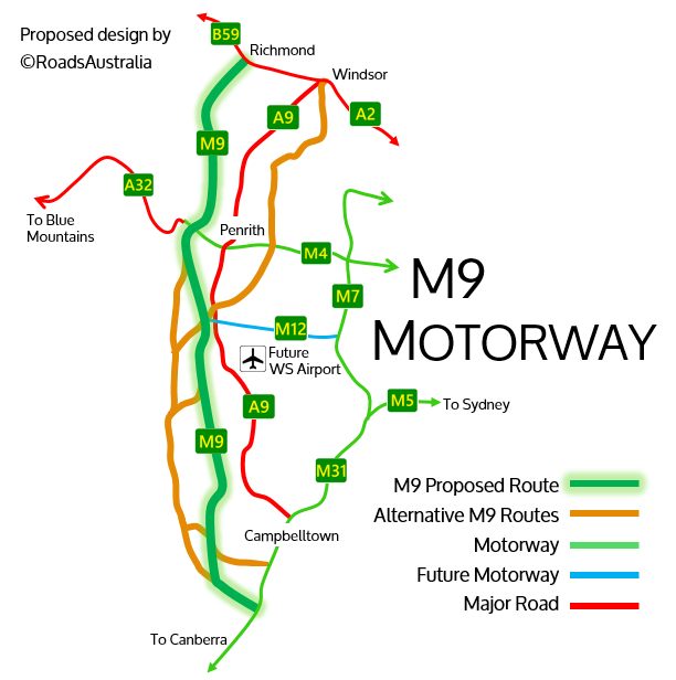
The southerly alignment links the M9 Motorway to the M31 Hume Motorway roughly 12km south of Campbelltown. This alignment assumes motorists are travelling south, allowing for a more effective bypass of Sydney. However a slightly more northerly alignment from the route could allow the M9 to meet the M31 6km from Campbelltown, which allows for a more effective link to Campbelltown.
The RoadsAustralia proposal chose to use the southerly alignment to enter the M31, prioritising the route as a bypass route, as well as giving more opportunity for development of suburbs further south of Campbelltown; usually new motorways result in more housing around the motorway.
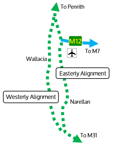
Picture
The South
​
In the south there are two corridor options for the M9 Motorway.
The Easterly Alignment passes very close to the west of Camden before continuing north close to the current-A9. It comes within 4km of the future Western Sydney Airport, continuing east of Mulgoa. Its advantages are that it is closer to both Camden and the future airport, allowing for enhanced connectivity. It is the shorter alignment out of the two options. However its close proximity could be controversial, potentially impeding housing developments and causing noise issues.
The Westerly Alignment passes further west from Camden, before skirting the extreme outer edge of Western Sydney. Passing 7km from the future airport just west of Wallacia, it continues west of Mulgoa. The advantages of this alignment are that it passes further away from city centres, reducing noise levels. However its distance from key centres could impede its overall usefulness and connectivity to the public, thus defeating the purpose of the motorway.
The RoadsAustralia design utilises the easterly alignment, choosing it due to its more enhanced connectivity, primarily to the future Western Sydney Airport.
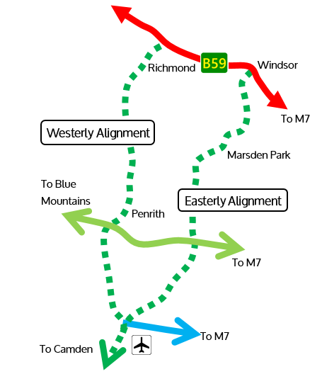
Picture
The North
​
In the north there are two corridor options for the M9 Motorway.
The Easterly Alignment can connect to both the Easterly and Westerly Southern Alignments. The primary difference between the two alignments is which side of Penrith it passes through. This alignment passes east of Penrith, just west of Erskine Park and St Marys. The route passes through the north of Marsden Park before ending at Windsor Road just south-east of Windsor. It advantages are that it can connect to the larger regions of Western Sydney better, however it may require more land acquisitions than the alternate alignment, most prominently in the currently expanding suburb of Marsden Park.
The Westerly Alignment can also connect to both the Easterly and Westerly Southern Alignments. The alignment passes to the west of Penrith, just west of Jamistown. The route continues north just east of Castlereagh, before terminating at the Bells Of Line Road just west of Richmond. Its advantages are that it requires less land, and will allow for more housing development out further west. However it is slightly longer, and its construction would require the demolition of the Penrith Whitewater Stadium.
The RoadsAustralia design uses the Westerly Alignment, a better link for Western Sydney which can increase connectivity to the furthest parts of Sydney, enhancing transport to Richmond.
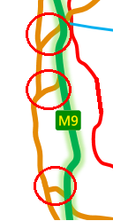
Picture
​Variations
Several possible variations in the route exist. The three short ‘links’ are circled in the pictured image, which simply bridge the various alignments together for a seamless route, for example starting on the South-Westerly alignment before bridging onto the South-Easterly in the middle link.
Picture
​Final Alignment
The final route stretches 70km. The alignment closely follows the current A9 alignment. The route is positioned such that it can efficiently connect Richmond, Penrith, the future Western Sydney Airport, and Campbelltown, with minimal housing acquisitions.
The motorway should be built to six lanes, with three lanes in each direction. As little as possible of the freeway should be located underground, to save money and allow for easier roadworks on the route should the need arise. If possible, the motorway will not be tolled, or if necessary a low toll may be implemented.

Interchanges
Interchanges along the chosen M9 corridor have been strategically chosen to allow effective connectivity to communities. Under this design there are 20 planned interchanges. These interchanges will be located at:
  • Hume Motorway (M31)
  • Menangle Road
  • Remembrance Drive
  • Burragorang Road
  • Cawdor Road
  • Macquarie Grove Road
  • Cobbity Road
  • Greendale Road
  • Park Road
  • Western Sydney Airport Motorway (M12)
  • Kings Hill Road
  • Mulgoa Road
  • Western Motorway (M4)
  • Jamison Road
  • Great Western Highway
  • Castlereagh Road
  • Springwood Road
  • Bells of Line Road & Kurrajong Road (B59)
For the most part, these interchanges will be modified diamond interchanges. Some interchanges, such as Burragorang Road, may be a full diamond, whereas other interchanges may be half diamonds, such as at Jamison Road.
There are a few interchanges which will not be diamond interchanges
  • Hume Motorway- Trumpet Interchange. The loop will be used for traffic coming south on the M31 wishing to enter the motorway. This type of interchange saves space, and is used for terminating interchanges
  • Park Road- Modified Trumpet. The loop in this instance shall serve to direct traffic northbound on the M9 to eastbound on Park Road, allowing easy access to the current A9. Normal diamond ramps will be used for the remainder of the interchange
  • Western Sydney Airport Motorway- Current designs indicate the M12 ending at the current-day A9. Under plans for the M9, the M12 will be extended to meet the M9, terminating at a Directional T Interchange. This will allow for efficient, quick traffic flow
  • M4 Western Motorway- Four level stack interchange. This interchange will be designed similarly to the Light Horse Interchange, allowing complete access to either motorway from all directions.
  • Bells Of Line Road & Kurrajong Road- Directional T Interchange. This design allows for efficient access to and from the B59 onto the M9, allowing traffic to either continue to Richmond or south to Windsor
For more information about interchanges read this page.

At my best estimate, we can expect the M9 Motorway to open earliest in 2035, however a more reasonable estimate would put its opening anywhere between 2040 and 2060. In other words, the opening is so long away we’ll probably already have been enslaved by robots. Even so, it is important that we do preserve corridors by disallowing any developments on land along the route, to ensure the route is ‘shovel-ready’ in the future, on the slight off-chance that we are not enslaved by robots.
NOTE; It should be stressed that a majority this page details an unofficial design for the M9 Outer Sydney Orbital drawn up by the maker of this hobby website. This proposal is by no means official and was made before preliminary designs were released by the government for the motorway in 2018. This page is yet to be updated to reflect this.
links
  1. https://www.transport.nsw.gov.au/projects/current-projects/outer-sydney-orbital-corridor-study
  2. http://www.rms.nsw.gov.au/projects/sydney-west/the-northern-road/index.html
  3. https://en.wikipedia.org/wiki/A9_(Sydney)
  4. http://www.dailytelegraph.com.au/news/nsw/m9-outerwestern-sydney-orbital-motorway-part-of-big-ticket-55b-roads-package-unveiled-in-todays-nsw-budget/news-story/274d9ae18ca0a5ebd0604be6ae887f52
  5. http://www.dailytelegraph.com.au/projectsydney/project-sydney-three-new-major-motorways-will-put-the-city-in-the-fast-lane/news-story/0c082802d7ad792ebce071ea9f9f1db6
  6. http://www.hillsnews.com.au/story/2467727/proposed-m9-motorway-confuses-many/​
Powered by Create your own unique website with customizable templates.